Navigation Chart Plotter

Navigation Chart Plotter

Product Ref: 03725.   Civilian Issue - New
This item may be available to buy on Amazon.Check Amazon now →
Amazon and the Amazon logo are trademarks of Amazon.com, Inc. or its affiliates. As an Amazon Associate we earn from qualifying purchases. #ad
Info from Amazon
Info from Amazon

Lindemann LINEP01 Original Portland Plotter

£23.00
Shop Now

Aviation Plotter Aviation Slide Rule with 8 Functions for Pilot Student Accessories Rotating Azimuth Plotter, WAC Charts, Air Navigation Plotter for Navigational Usage

£12.18
Shop Now

GPS Marine Navigator, Keyed Chartplotter, 5in Marine Satellite GPS Navigator Color LCD Display XF-520 Dual-Mode Positioning Boat Chart Plotter

£288.88
Shop Now

Portland Course Plotter (with 7'' divider) Kit

£28.60
Shop Now

Marine Chart Plotter, Marine GPS Navigator, GPS Chart Plotter Satellite Navigator AIS Transponder with GNSS Antenna Dual Map System IPX6 Waterproof for Marine Boat GPS Navigation Marine

£380.34
Shop Now

KJKVIVH 2 Pack Plotter Plotting Tool Aviation Plotter Charts Air Navigation Plotter Pilot Accessories Plastic Transparent for Pilots Navigation

£9.59
Shop Now
Amazon and the Amazon logo are trademarks of Amazon.com, Inc. or its affiliates. As an Amazon Associate we earn from qualifying purchases. #ad
Further Information
Further Information
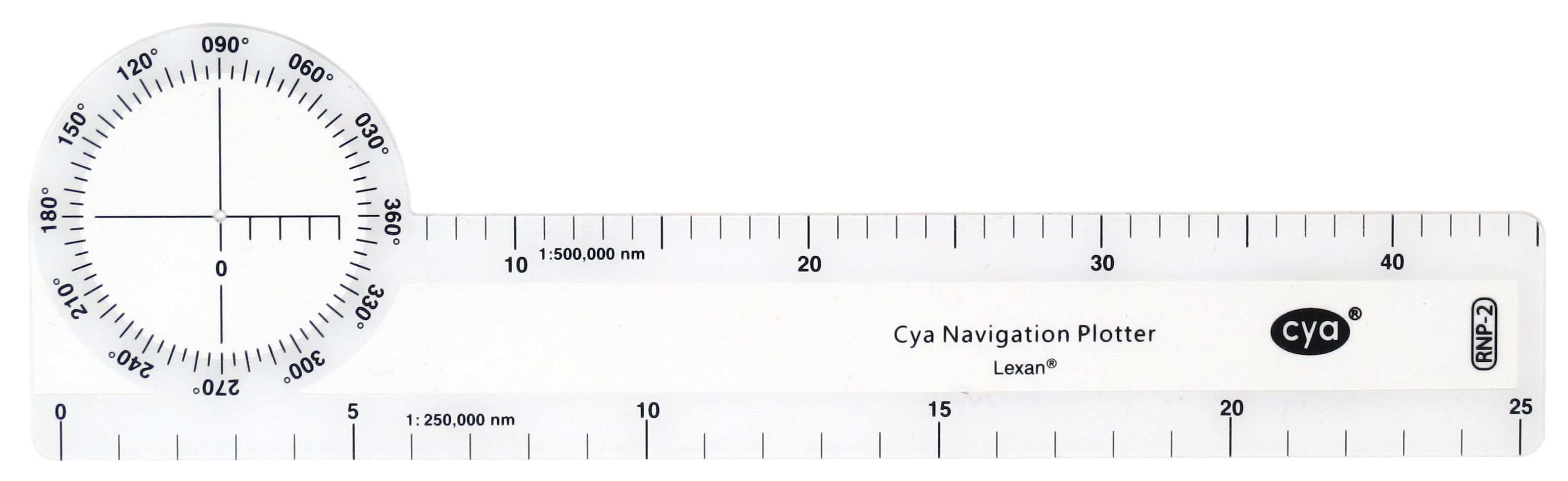
  • For use on topographical charts
  • Scales for 1:1,000,000 to 100 nm and 1:500,000 to 25 nm
  • Flexible plastic
  • Overall dimensions 190 x 55mm
Pocket sized chart plotter for fast, combined readings of headings and distances. Designed for use on topographical charts. By aligning the top edge over the proposed track, Magnetic or True headings (zero wind) and distances are simultaneously obtained. Incorporates scales for 1:1,000,000 to 100 nm and 1:500,000 to 25 nm.
Reviews
Reviews
You might also be interested in...